
Inverse methods for ice sheet surface elevation changes with an application to West Antarctica
| Working Group: | WG Modelling and Scientific Computing |
| Leadership: |
Prof. Dr. Andreas Rademacher ((0421) 218 63831, E-Mail: arademac@uni-bremen.de)
Prof. Dr. Angelika Humbert |
| Processor: | Lea-Sophie Höyns (E-Mail: lea-sophie.hoeyns@awi.de) |
| Funding: | Helmholtz Schule für Marine Data Science (MarDATA) finanziert von der Helmholtz Association |
| Project partner: | AG Eisschild Modellierung, AWI, Alfred-Wegener-Institut, Bremerhaven |
| Time period: | 01.06.2021 - 31.05.2024 |
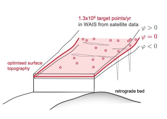 The West Antarctic Ice Sheet (WAIS) is currently the major factor in the contribution of Antarctica to sea-level change. Observations are based on satellite altimetry, which measures elevation change, that is transferred into mass loss. But this satellite altimetry data comes in type of point-clouds and they are sparse at areas, where the ice loss is highest and the mass loss can only be determined inaccurately.
To overcome this issue, the project aims to develop new, innovative data assimilation methods for the WAIS surface topography. Therefore, we apply an optimal control approach for optimizing the WAIS surface within an ice sheet model based on finite elements, the Ice-sheet and Sea-level System Model (ISSM). We develop an interface for streaming the point-cloud type satellite altimetry data into ISSM, conduct the optimization for 40+ years of satellite altimetry life time, ending with an ice sheet surface elevation data product for WAIS. The resulting surface elevation product is a crucial input for IPCC mass loss assessments. In addition, the dynamic evolution thus the 3D velocity field of WAIS over the satellite data time period which is calculated in the ice sheet model as a data product, can serve as initial state for reliable projections of future sea level rise. And the mechanical side products which arise due to the optimization procedure will serve as a basis for metrics to assess the health state of WAIS in future. By conducting this data analysis of the simulated physical variables, we identify critical areas in WAIS.
The West Antarctic Ice Sheet (WAIS) is currently the major factor in the contribution of Antarctica to sea-level change. Observations are based on satellite altimetry, which measures elevation change, that is transferred into mass loss. But this satellite altimetry data comes in type of point-clouds and they are sparse at areas, where the ice loss is highest and the mass loss can only be determined inaccurately.
To overcome this issue, the project aims to develop new, innovative data assimilation methods for the WAIS surface topography. Therefore, we apply an optimal control approach for optimizing the WAIS surface within an ice sheet model based on finite elements, the Ice-sheet and Sea-level System Model (ISSM). We develop an interface for streaming the point-cloud type satellite altimetry data into ISSM, conduct the optimization for 40+ years of satellite altimetry life time, ending with an ice sheet surface elevation data product for WAIS. The resulting surface elevation product is a crucial input for IPCC mass loss assessments. In addition, the dynamic evolution thus the 3D velocity field of WAIS over the satellite data time period which is calculated in the ice sheet model as a data product, can serve as initial state for reliable projections of future sea level rise. And the mechanical side products which arise due to the optimization procedure will serve as a basis for metrics to assess the health state of WAIS in future. By conducting this data analysis of the simulated physical variables, we identify critical areas in WAIS.